"I think we're lost" / "How do you know?" / "Because Mom and Dad are fighting again!"
- My two sisters in the back of the car when they were toddlers, 25 years ago (before I was born)
_______________________________________________________________
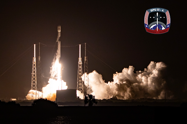
Earlier this month, SpaceX launched a next-generation GPS satellite for the US Space Force, and that gave me the idea to dedicate today's post to my mother. Why's that, you ask? Mom is quite skilled at many things - an excellent chef, a pretty solid golfer, and an all-around awesome woman. But she'll be the first to admit that her navigation skills are rather... lacking, to say the least. Growing up, we always had to leave the house extra early for everything from crack-of-dawn golf tournaments to red-eye plane flights as a margin of safety against the inevitable contingency that she might get lost along the way! And when it came time to replace our old minivan, Dad made sure that Mom's brand new top-of-the-line 2004 Toyota Sienna came with all the bells and whistles, including (above all else) a built in GPS navigation system!! Eight-year-old me couldn't believe my eyes: the car has a computer that's hooked up to the satellites? The future is here!
 |
| After a pad abort and a month-long delay, here's GPS III SV04 lifting off on Nov. 5, 2020! |
Of course, GPS has been around a lot longer than my family's 2004 minivan. Originally a strictly military project initiated by the US Department of Defense in 1973, it has since seen much more widespread adoption following an executive order by President Reagan in the 1980s allowing civilian applications (albeit with reduced signal accuracy until this limitation was lifted in 2000). But while everyone appreciates its utility, most of us (myself included) take this modern miracle for granted with little to no understanding of how GPS works or what hardware is needed to maintain it. After all, if it's been perfectly operational for decades, what are we still launching?
 |
| The Gulf War saw the first widespread use of GPS in a combat zone |
Here's the basic concept of how GPS works: a constellation of specialized satellites, each carrying super-precise synchronized atomic clocks, continuously transmits radio waves signaling the satellite's current time and position above the Earth. The radio waves travel at the speed of light, so by calculating the difference between the time of transmission stated by the signal and the time of arrival detected by the user, the user knows exactly how far away the GPS satellite is. But a signal from one satellite is not enough; there are an infinite number of locations that are a given distance from a point (if you recall from geometry, that's the very definition of a sphere!), so you still don't know where you are. As you can see from the diagram below, it takes 4 satellites to pin down the user's exact location
 |
| This process is known as trilateration (based on distance) as opposed to triangulation (based on angles) |
So it takes 4 satellites to nail one location, but in order to provide constant coverage across the entire globe, GPS requires a minimum of 24 satellites across 6 evenly spaced orbital planes in Medium Earth Orbit. On top of that, the US Space Force (the entity now responsible for maintaining GPS) operates control stations and dedicated ground antennae to track the satellites and provide navigational and timekeeping updates as needed to ensure the atomic clocks remain synchronized to within nanoseconds of each other. Interestingly, this leads to the creation of a unique GPS time separate from the Coordinated Universal Time that the world's clocks are set to, since unlike UTC, GPS time is not corrected to match the gradual deviations in the rotation of the Earth. As of now, GPS time is exactly 18 seconds ahead of UTC
 |
| Left: an animation of GPS satellites providing continuous coverage | Right: an atomic clock like what a GPS satellite would carry |
So back to the original question - if GPS has been operational for decades, what are we still launching? The first GPS satellite was launched in 1978, but like all satellites, after a while orbits begin to degrade, systems gradually fail, and stabilizing propellant runs dry. On top of that, satellite technology has progressed immensely since the 1970s, so over time the old GPS satellites need to be replaced with newer models (known as blocks). Looking at the table below, you'll see we're currently on Block III: the first Block III was launched in 2018, while the fourth and most recent Block III was launched this month and is currently undergoing on-orbit testing. And as of November 15, 2020, the current GPS constellation is comprised of 8 Block IIRs, 7 Block IIRMs, 12 Block IIFs, and 3 Block IIIs, with several older satellites available in reserve. Every satellite beyond the required 24 provides redundancy and additional trilateration accuracy
 |
| Now when you use Google Maps, you'll know all about the satellites that make it possible! | Credit: Wikipedia |
 |
| Always looking for the latest and the greatest! | Credit: Lockheed Martin |


No comments